News
Structure of the oceanic crust and rift belts
ÍSOR · 24 May 2022 · 2 min read
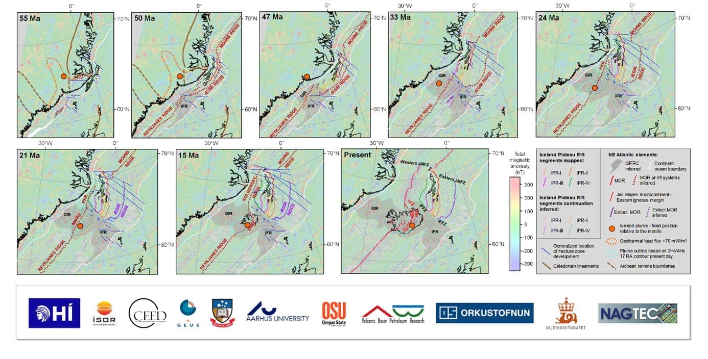
Anett Blischke, structural geologist and specialist in seabed research at ÍSOR, and her colleagues are the authors of a recent scientific article on the structure and rift history of the sea area north of Iceland and west of Jan Mayen. The article, which is the product of a collaborative project of…
Anett Blischke, structural geologist and specialist in seabed research at ÍSOR, and her colleagues are the authors of a recent scientific article on the structure and rift history of the sea area north of Iceland and west of Jan Mayen. The article, which is the product of a collaborative project of ÍSOR, the National Energy Authority (Orkustofnun), the Institute of Earth Sciences of the University of Iceland, and numerous foreign geoscience institutions and universities, is titled "Seismic Volcanostratigraphy: The Key to Resolving the Jan Mayen Microcontinent and Iceland Plateau Rift Evolution".
The joint interpretation of geophysical and geochemical data forms the basis for a new understanding of the formation history of the area north of Iceland. Jan Mayen split off from Greenland in repeated rift-belt migrations, alongside a declining spreading rate on the southern part of the Ægir Ridge. Manifold faulting movements reflect strong intrusive activity within volcanic systems that resemble the rift belts of Iceland today.
Further research is planned in the field of seabed geology, including on the effects of the hot spot on rift-belt migrations, the location of continental crust at Jan Mayen and on the Iceland-Faroe Ridge, and ocean-current and climate changes in connection with the formation of the Iceland-Faroe Ridge. Other projects concern research on traces of glaciation on Iceland's continental shelf, assessment of various natural hazards, and research on resources in connection with Iceland's law-of-the-sea claims.
At ÍSOR works a group of geoscientists who over the past decades have built up specialist knowledge in the acquisition and interpretation of seabed data. Among the projects can be mentioned advice to the authorities regarding the definition of the continental shelf beyond 200 nautical miles and research and advice in connection with the preparation of licences for the exploration and extraction of resources on the seabed.
The figure shows an overview map of the formation of the North Atlantic from when continental drift began about 55 million years ago to the present day. References and sources can be found in the article, which is accessible here: