News
Extensive research on Iceland's crust and geothermal exploration
ÍSOR · 28 June 2023 · 2 min read
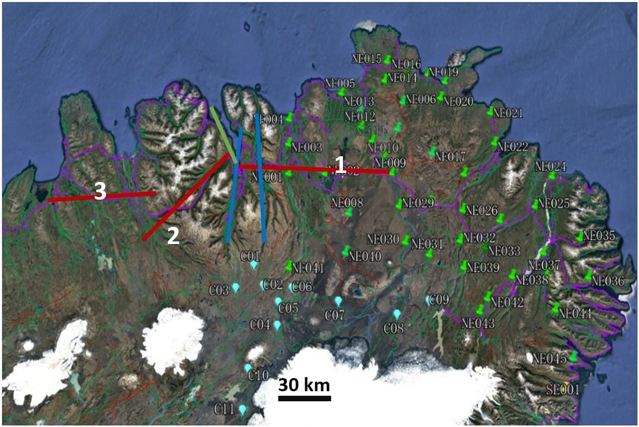
This August, extensive research on the crust beneath Iceland begins. A group from the China University of Geosciences in Wuhan, China (CUG) is coming to the country. Measurements are to be made of resistivity/conductivity deep in the earth beneath Northeast Iceland (green pins in the accompanying…
This August, extensive research on the crust beneath Iceland begins. A group from the China University of Geosciences in Wuhan, China (CUG) is coming to the country. Measurements are to be made of resistivity/conductivity deep in the earth beneath Northeast Iceland (green pins in the accompanying figure) with so-called MT measurements, and ÍSOR is taking part in the project (against payment from CUG). This is a five-year project in which such measurements are to be made and the crust beneath the whole country is to be researched.
Nearly half a century ago, when MT measurements were first made here in Iceland (in cooperation between the University of Cologne in Germany and the National Energy Authority), it was found that beneath most of the country there is a layer with high conductivity (a low-resistivity layer) at 8-15 km depth. It was interpreted as partially molten rock beneath a thin, too-hot crust. Later research (seismic, earthquake and gravity measurements) indicates, however, that the crust is about twice as thick and, comparatively, "cold". Questions remain such as: What is this low-resistivity layer and what can it teach us about the internal structure, origin and evolution of the crust beneath Iceland?
When ÍSOR began to apply MT measurements to geothermal research (2005), it was found that the deep low-resistivity layer domes up locally, to about 2-4 km depth, beneath high-temperature geothermal systems, except on the outer Reykjanes Peninsula. There it is not present. The low-resistivity layer also domes up from 15-20 km up to 5-6 km depth beneath the low-temperature area in Eyjafjörður, south of Akureyri, the only low-temperature area that has been investigated with MT measurements. This raises the questions: Is there a connection between the depth of the low-resistivity layer and geothermal energy? Can mapping of the low-resistivity layer point to hidden geothermal systems?
ÍSOR aims, in cooperation with Norðurorka, the University of Iceland and four foreign universities, to address these questions and what may cause the good conductivity in the layer. A project has been defined in which the low-resistivity layer is to be investigated in greater detail than in the CUG project, with denser MT measurements and gravity and magnetic measurements, on survey lines over known geothermal areas in North Iceland. Red lines on the accompanying figure show survey lines that will be funded by the project. Norðurorka will fund resistivity measurements on the green and blue lines. If a systematic relationship is found between geothermal energy and the low-resistivity layer, a new method for searching for geothermal energy may be found, both high-temperature within volcanic belts and low-temperature in areas where there are few or no traces on the surface. There are examples of such, e.g. in Helgafellssveit.
ÍSOR has applied for a grant from RANNÍS for the project.