News
New geological map of the country's Western Volcanic Zone
ÍSOR · 14 February 2022 · 2 min read
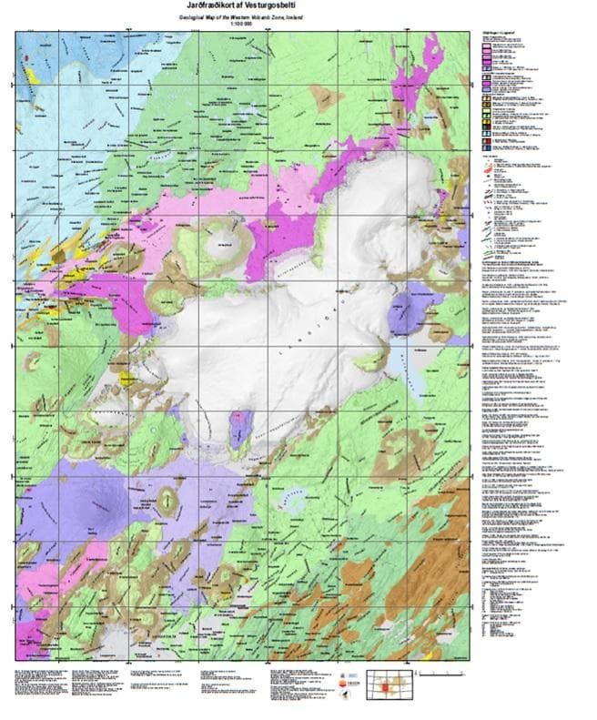
A new geological map of the country's Western Volcanic Zone at the scale 1:100,000 has been published. It covers the lava areas north of Þingvallavatn and all the way north over Langjökull. To the west it extends over Arnarvatnsheiði and to the east over Hreppafjöll. Here one can access a pdf…
A new geological map of the country's Western Volcanic Zone at the scale 1:100,000 has been published. It covers the lava areas north of Þingvallavatn and all the way north over Langjökull. To the west it extends over Arnarvatnsheiði and to the east over Hreppafjöll. Here one can access a pdf version of the map, which will then appear on the institutions' map web viewers ÍSOR http://jardfraedikort.is/ and NÍ https://jardfraedikort.ni.is/, which carried out the work.
The geological map is part of a special project in geological mapping of Iceland that the Ministry for the Environment and Natural Resources (UAR) has carried out since 2018 in collaboration with Iceland GeoSurvey (ÍSOR) and the Icelandic Institute of Natural History (NÍ). Among the natural gems on the map are Gullfoss, Geysir, Laxárgljúfur, Skjaldbreiður, Hallmundarhraun, Hraunfossar, Eiríksjökull and Prestahnúkur.
The bedrock of the area, which is for the most part hyaloclastite (móberg) and lava layers, is divided into several age groups. The oldest geological strata on the map are from the Late Miocene and about 5.5 million years old. The modern-era lavas in the area number 25 and are classified into four age categories with the help of tephra layers. The oldest lavas are over 10,000 years old. Hallmundarhraun is the only historical lava on the Western Volcanic Zone. The lava originates in a large crater up beneath the northern part of Langjökull at Jökulstallar, which in later years has been given the name Hallmundur. Hallmundarhraun is one of the country's largest lavas from historical time, about 185 km² in area. It is thought to be from the first half of the 10th century, flowed nearly 50 km from its source to the west and caused damage in the settlement. The lava is very rich in caves, and there one finds the country's longest lava caves, the most famous of them Surtshellir. Geothermal activity and springs are shown on the map along with the main features of faulting and glacial retreat.
Among the new observations of recent years that appear on the map are traces of a central volcano in Hrútafjörður, a geothermal spring at Sultarfit, new age determinations of modern-era lavas and previously unknown lava islets in Hallmundarhraun. An article in Náttúrufræðingurinn by Magnús Á. Sigurgeirsson, geologist at ÍSOR, on Hallmundarhraun is forthcoming.
The geological map of the Western Volcanic Zone is based in part on older maps, previously unpublished data and maps at a larger scale that have appeared in reports and accounts of ÍSOR, NÍ and the National Energy Authority, along with selected journal articles. There the map of the Western Volcanic Zone by Sveinn P. Jakobsson, geologist, weighs heaviest.
The geologists Birgir V. Óskarsson, Ögmundur Erlendsson, Robert Alexander Askew, Árni Hjartarson, Magnús Á. Sigurgeirsson and Skafti Brynjólfsson worked on the making of the map. The map designers are Anette Theresia Meier, Lovísa Ásbjörnsdóttir, Albert Þorbergsson and Gunnlaugur M. Einarsson.