News
Eruption period on the Reykjanes peninsula 1900-2500 years ago – an overview
ÍSOR · 20 June 2021 · 3 min read
The second-to-last eruption period on the Reykjanes peninsula, which lasted 1900-2500 years ago, was not very different from the last one, which lasted from 800 to 1240 AD. The main difference lies in the fact that then the Hengill system became active, whereas in modern times eruptive activity…
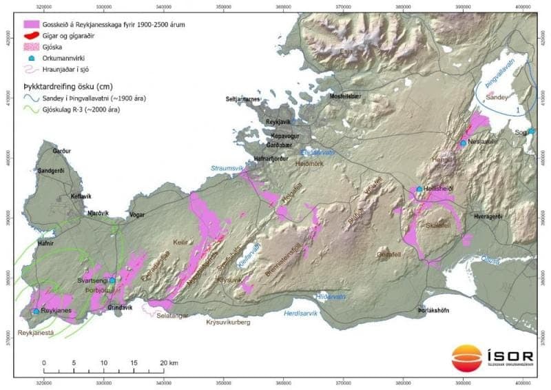
The second-to-last eruption period on the Reykjanes peninsula, which lasted 1900-2500 years ago, was not very different from the last one, which lasted from 800 to 1240 AD. The main difference lies in the fact that then the Hengill system became active, whereas in modern times eruptive activity there has been less than in the systems to the west. The accompanying map shows the distribution of lavas from this time.
In the Hengill system, Nesjavallahraun flowed both north and south of Hengill about 1900 years ago. One of the most interesting things about the eruption is that the eruptive fissure extended out into Þingvallavatn and caused an explosive eruption that built up a tephra cone. The crater still stands and is called Sandey. The tephra dispersed about the immediate surroundings of Þingvallavatn, most of it however to the east (see map).
In the Brennisteinsfjöll system, Skúlatúnshraun (also called Stórabollahraun), Óbrinnishólahraun, a small lava east of Kistufell and Kálfadalshraun north of Geitahlíð flowed. As far as can be determined, Skúlatúnshraun is the oldest of the lavas, about 2500 years old, and marks the beginning of the eruption period. Skúlatúnshraun and Óbrinnishólahraun flowed to the sea at Straumsvík. It may be mentioned that the last eruption period also began in Brennisteinsfjöll.
In the Krýsuvík system, Afstapahraun flowed from an about 15 km long discontinuous crater row just over 2000 years ago. The lava bears many names, such as Eldborgarhraun and Dyngnahraun to the north and Skolahraun, Leggjabrjótshraun, Skollahraun and Katlahraun to the south. The lava flowed to the sea both at the northern and southern coasts of the peninsula. Kúagerði by Reykjanesbraut is a well-known landmark in the lava. At the southern coast it flowed up to 2 km into the sea west of Selatangar. If the eruption at Geldingadalir continues as it has, it is not ruled out that Fagradalshraun will abut or overlie the southernmost tongues of Afstapahraun.
In the Svartsengi system, Sundhnúkahraun flowed from an about 11 km long crater row, and another lava from a crater row a short distance west of Eldvörp, but it is to a large extent covered by younger lavas. These lavas are 2000-2200 years old. In the Reykjanes system, Eldra-Stampahraun and Hörslahraun flowed about the same time. The eruptive fissure that Eldra-Stampahraun flowed from reached the sea at Kerlingarbás on Reykjanes and built up a tephra cone there a short distance from land. The tephra from the eruption (the tephra layer R-3) dispersed over the western part of the Reykjanes peninsula but east of Keilir it is hardly found (see map). Research shows that eruptions in the sea, that is Surtseyan eruptions, are generally companions of fissure eruptions on Reykjanes.
According to age determinations, it cannot be seen otherwise than that the Reykjanes and Svartsengi systems were active about the same time 2000-2100 years ago. The same was the case in the Reykjanes Fires 1210-1240 AD. It may also be mentioned that age determinations show that Afstapahraun in the Krýsuvík system is from this same period. Therefore most things indicate that not a long time passed between events during these hundred years, hardly more than a few decades. Whether the course of events will be the same in the activity period that is now beginning shall be left unsaid, but it cannot be ruled out.
In dating lavas/eruptions from prehistoric time, before settlement in the country, people have relied on tephrochronology and C-14 age determinations. The tephrochronology for the Reykjanes peninsula is useful for the last 4000 years but is less precise for the earlier part of modern times, and C-14 age determinations have then proved important. Material for C-14 age determinations is, however, difficult and time-consuming to obtain, and the number of available determinations is not large. It must be clear that if a better picture of eruptive activity on the Reykjanes peninsula in the earlier part of modern times, 4000-11,000 years ago, is to be obtained, an effort must be made to search for charred plant remains beneath lavas and to date them. As is well known, old lavas have a tendency to be covered by younger lavas, which makes access to them ever worse. If a new activity period is beginning on the peninsula with frequent lava eruptions, it would be desirable to set this work in motion sooner rather than later.
Text: Magnús Á. Sigurgeirsson. Map: Albert Þorbergsson.