News
Eruption at Litli-Hrútur and earthquake monitoring at ÍSOR
ÍSOR · 11 July 2023 · 2 min read
ÍSOR has worked with the Czech Academy of Sciences in Prague since 2013, and the academy has operated 17 seismometers on the Reykjanes Peninsula in cooperation with ÍSOR. The seismometer network, which is called REYKJANET, covers the peninsula fairly well all the way to Geitafell in the east, see…
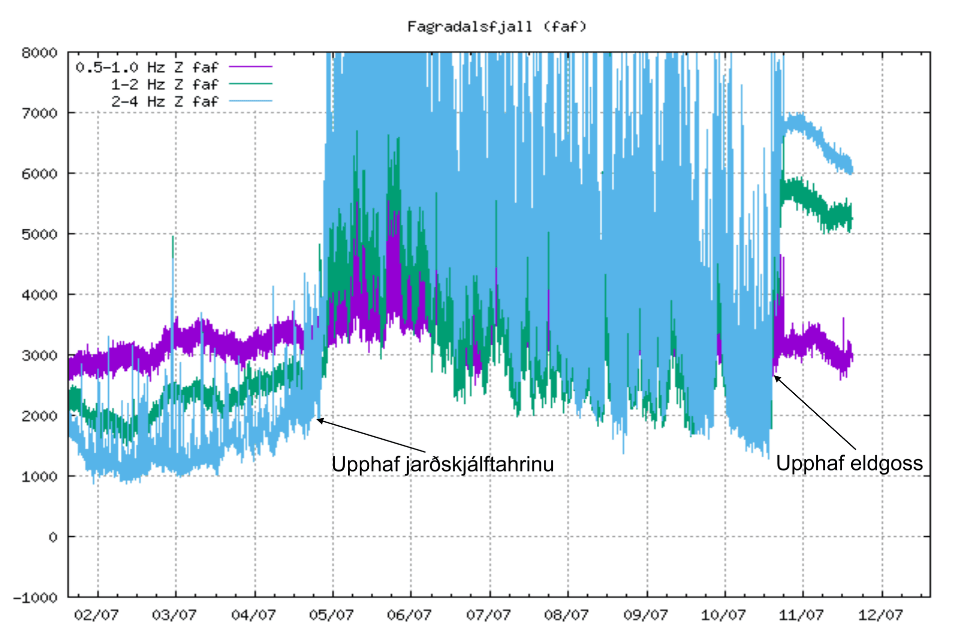
ÍSOR has worked with the Czech Academy of Sciences in Prague since 2013, and the academy has operated 17 seismometers on the Reykjanes Peninsula in cooperation with ÍSOR. The seismometer network, which is called REYKJANET, covers the peninsula fairly well all the way to Geitafell in the east, see the green triangles in the figure. These seismometers have recorded earthquakes on the Reykjanes Peninsula continuously over the last years, together with the seismometers of the Icelandic Meteorological Office on the peninsula (blue triangles in the figure). The cooperation between ÍSOR and the Czechs over the last 2 years has taken place within the EEA-funded research project NASPMON, within which, among other things, all the seismometers were set into real-time streaming. To obtain better resolution of earthquake locations for natural hazard monitoring due to the seismic unrest that began in February 2021, streaming of earthquake data from 8 of the 17 seismometers in REYKJANET to the Meteorological Office from ÍSOR was begun. This is done by a special agreement for natural hazard monitoring, and together these measuring stations have played a key role in natural hazard monitoring on the Reykjanes Peninsula since the unrest began, and also for further understanding of what is going on there. During these times of unrest, one seismometer, FAF east of Fagradalsfjall, has been invaluable in natural hazard monitoring due to its location, both for more precise earthquake location and not least for monitoring eruptive tremor (see figure). Now, however, the lava flow in the ongoing eruption is heading straight for FAF, so we are forced to remove the station in cooperation with the Icelandic Meteorological Office and the University of Iceland. It will be sorely missed! On the accompanying tremor graph of FAF from the Icelandic Meteorological Office, it can be clearly seen when, on the one hand, the earthquake swarm that accompanied the magma movements began, and then when the eruption began yesterday, on 10 July at 16:40. The accompanying figure also shows automatic earthquake locations of the magma dike and triggered earthquakes east of Keilir (red dots), calculated in near-real-time at ÍSOR, which began its advance on 4 July and reached the surface in an eruption at Litli-Hrútur yesterday, on 10 July.