News
Volcanic eruptions on the Svartsengi–Sundhnúkur eruptive fissure after the Ice Age
ÍSOR · 18 January 2024 · 4 min read
In light of the recent events on the Reykjanes Peninsula, there is reason to recall what is known about the eruptive history of the Sundhnúkur eruptive fissure. The Svartsengi system is about 30 km long and 6-7 km wide. After the glaciers of the Ice Age melted some fifteen thousand years ago…
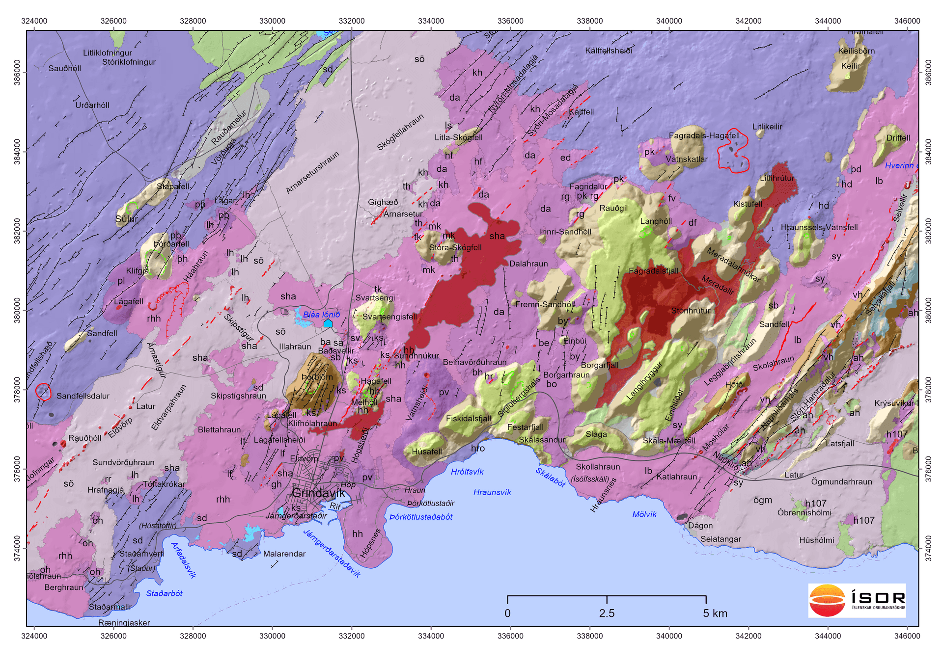
In light of the recent events on the Reykjanes Peninsula, there is reason to recall what is known about the eruptive history of the Sundhnúkur eruptive fissure. The Svartsengi system is about 30 km long and 6-7 km wide. After the glaciers of the Ice Age melted some fifteen thousand years ago, eruptive activity in the system has been confined to the Eldvörp eruptive fissure on the one hand and the Svartsengi/Sundhnúkur eruptive fissure on the other. The latter lies just east of the hyaloclastite mountains Þorbjörn, Sýlingarfell (also called Svartsengisfell) and Stóra-Skógfell. Although various things are known about the history of eruptive activity on the Sundhnúkur eruptive fissure, much is still unclear, especially regarding the oldest lavas. This actually applies to the whole Reykjanes Peninsula. Lavas originating on the fissure will be briefly described below in chronological order. In the discussion, reference is made to labels on the accompanying map: Patches of worn and ancient lavas can be found in many places on the flanks of the hyaloclastite mountains east of Svartsengi, e.g. on the western and northern sides of Þorbjörn, at Sýlingarfell and Stóra-Skógfell (e.g. ks, sb, mk on the map). On the lowlands these lavas are covered by younger lavas and their extent is therefore unknown. These lavas are mostly composed of welded spatter, which indicates that they formed during intense lava-fountaining activity. Lava of this kind can be called spatter lava. They are probably from early in the postglacial period, even the late-glacial period. No age determinations are yet available for the lavas. An indication of the age of one of them, however, appears in a quarry at Hagafell, where it lies well beneath an 8,000-year-old lava (see below), and its age is estimated at about 10,000 years (Magnús Á. Sigurgeirsson, unpublished data). Both on the southwestern and eastern sides of Hagafell there are short ancient crater rows. The lava from them has been named Hópsheiðar and Hópsness lava (hh on the map). A C-14 age determination on plant remains beneath the lava revealed that they are about 8,000 years old and the lava is likely of similar age. The largest expanses of this lava appear at Hópsheiði and Hópsnes by Grindavík. The lava also appears in lava islets at Sundhnúkur, about 500-700 m north of Hagafell, which shows that the eruptive fissure was at least 1.5 km long. At the northern end of Sundhnúkur lava, four lavas can be seen emerging from beneath it (marked kh, ed, hf and da). The age of these lavas is unclear but they are nonetheless considerably more than 4,000 years old. One can also mention an ancient lava originating at Lágafell west of Þorbjörn (lf on the map). There is work to be done here on more precise age determinations. The Sundhnúkur crater row is one of the longer crater rows of the Reykjanes Peninsula, about 11.5 km long in total, and the lava covers about 22 km2 of land. An age determination on charred twigs beneath the lava gave the age 2,300-2,400 years. However, tephra layer studies indicate that the lava is closer to 2,000 years in age (Magnús Á. Sigurgeirsson, unpublished data). The crater row lies west of Hagafell and continues, broken up, 3 km to the southwest. The southernmost craters are on a 250 m long crater row, which is separate from the main crater row (in the fenced-off area of the communications station north of Grindavík). These craters lie just over 400 m from the nearest houses in Grindavík and the lava margin is much closer, at Nesvegur. It is noteworthy that in the eruption of 14 January, an eruption began on a short crater row 600 m south of the main crater row, just as happened 2,000 years ago. Many examples could be cited of eruptive behavior of this kind, i.e. where an eruption occurs on a short crater row that is separate from the main crater row. During the period 1210-1240 AD, volcanic eruptions were frequent in the Reykjanes and Svartsengi systems, often called the Reykjanes Fires 1210-1240. The Sundhnúkur eruptive fissure was not active at that time, but instead there were eruptions on the Eldvörp eruptive fissure 4 km farther west. Studies of lavas and tephra layers indicate that the activity in the 13th century began at Reykjanes but then moved eastward over to the Svartsengi system around 1230 and then ended in 1240 when Arnarsetur lava flowed. Written sources are scant but nonetheless mention at least six volcanic eruptions during these 30 years, most of them in the sea off Reykjanes. It can be considered likely that the eruptions were more numerous, considering the frequent eruptions now occurring on the Reykjanes Peninsula. In light of history, it can be considered likely that the ongoing activity on the Sundhnúkur fissure may drag on, for several years at least. In past fires, over the last 2,000 years, it has most commonly been the case that lava covers about 40-50 km2 in each fire episode, or more, which further supports the conclusion that volcanic activity in the Svartsengi system could last somewhat longer.
Text: Magnús Á. Sigurgeirsson. Map: Gunnlaugur M. Einarsson.
Main sources: Kristján Sæmundsson and Magnús Á. Sigurgeirsson (2013). Reykjanesskagi. In: Náttúruvá á Íslandi, eldgos og jarðskjálftar. Viðlagatrygging Íslands and Háskólaútgáfan. Kristján Sæmundsson, Magnús Á. Sigurgeirsson, Árni Hjartarson, Ingibjörg Kaldal, Sigurður Garðar Kristinsson and Skúli Víkingsson (2016). Geological map of the Reykjanes Peninsula, 1:100 000 (2nd edition). Íslenskar orkurannsóknir.